Geographical scope of ML problem, existing in the Black Sea region, extends over the entire catchment area of the Black Sea drainage basin and includes the Black Sea proper; two satellite seas (the Sea of Azov and Marmara Sea); two straits connecting the Black Sea with the satellite seas (the Strait of Kerch and Istanbul Strait); all rivers (along with their tributaries), flowing into the above maritime areas; coastal territories bordering to these maritime areas; and all lands drained by the rivers and their confluents. In other words, the geographical scope includes those parts of Europe and Asia from which ML can arrive in or depart from the Black Sea region directly or by dint of water masses involved in the hydrologic regime of the basin. Air masses shifting over the region add to the problem of ML accumulation and dissemination.
Geographical and hydrological peculiarities of the Black Sea and contiguous water bodies have been reviewed repeatedly by many authors (e.g., Vylkanov et al., 1983; Zaitsev and Mamaev, 1997; Birkun, 2002 b; Zaitsev, 2006). Despite some factual contradictions, their general attitude on the features of these maritime areas may be summarized as follows.
The
Black Sea is one of
the most isolated inland seas in the world (Fig. 1.1). It is situated between
southeastern Europe and
Asia Minor and has a
surface area of 420,000-436,000 km2 and a volume of
537,000-555,000 km3 of water. The average depth is between
1,240 and
The shelf is slightly inclined offshore; its relief is
composed of underwater valleys, canyons and terraces. The continental slope is
tight and steep, descending in some places at an angle of 20-30º.
Pelitic muds cover the slope and the deep-sea depression, whereas bottom
pebbles, gravel, sand, silt and rocks are common for shelf area. There are few
small islands in the
Black Sea; the biggest one
and the most distant from the mainland is the Zmeiny isle (0.18 km2)
located
At the northeastern corner, the Black Sea is connected
to the Sea of Azov by the
Strait
of
Kerch, which is
The
Sea of Azov is about
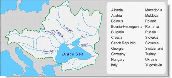
Fig. 1.1. Black Sea drainage basin and a list of twenty two Basin’s countries – potential contributors to Black Sea ML pollution via their river run-off (after Zaitsev and Mamaev, 1997).
In the southwest, the
Black Sea
is connected to the
Sea of Marmara (and thus
the
Çanakkale
Strait -otherwise known
as
Dardanelles Strait- and the
Mediterranean) by the
Over 300 rivers flow into the Black and Azov Seas including the second, third and fourth major European rivers, namely the Danube, Dnieper and Don. Some rivers (Danube, Don, Kuban, Kızılırmak and Yeşilırmak) form deltas before their confluence with the sea. The Danube delta (approx 5,920 km2) is the largest wetland in the region.
According to different estimations, the total catchment area of the Black Sea drainage basin comes to 1,875,000-2,500,000 km2 covering partially or entirely the territories of 22 countries (see Fig. 1.1).
The estimated annual volume of river discharge entering the Black Sea fluctuates from 294 to 480 km3. Vast quantities of silt, nutrients, organic matter and unknown amount of ML are brought down by rivers (in particular, the Danube expels up to 52 million tonnes of sediments per year). The annual volume of atmospheric precipitations in the Black Sea area (119-300 km3) is usually lower than the volume of river inflow. The annual level of the evaporation in the Black Sea has been calculated between 232 and 484 km3. Besides this, the general water balance also depends on the intensity of water exchange through the Kerch Strait and Istanbul Strait.
There are two counter currents in the
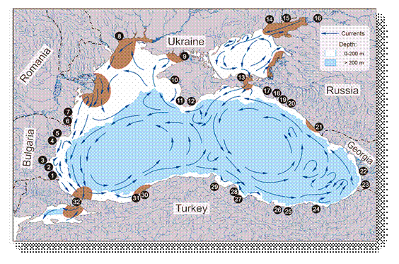
Fig. 1.2. Basic scheme of superficial sea currents and main land-based sources and hot spots of marine pollution in the Black Sea region:
| 1 | Tsarevo | 9 | Krasnoperekopsk | 17 | Anapa | 25 | Giresun |
| 2 | Sozopol | 10 | Evpatoria | 18 |
|
26 | Ordu |
| 3 | Bourgas | 11 |
|
19 | Gelendzhik | 27 |
|
| 4 |
|
12 |
|
20 | Dzhoubga | 28 | Bafra |
| 5 | Balchik | 13 |
|
21 |
|
29 | Gerze |
| 6 | Mangalia | 14 | Mariupol | 22 | Poti | 30 | Zonguldak |
| 7 | Constantza and Mamaia | 15 |
|
23 |
|
31 | Eregli |
| 8 |
|
16 | Rostov-na-Donu | 24 |
|
32 |
|
Taken from: Birkun (2002 b) based on Vylkanov et al. (1983), Black Sea Transboundary Diagnostic Analysis (1997), Bilyavsky et al. (1998), Kerestecioğlu et al. (1998) and Mee and Topping, (1999).
As a result of huge inflow from rivers, the mean
salinity of the
Black Sea (18‰) is less than a half that of the
Mediterranean. It rises up to 21-27‰ at a depth below
The range of water temperatures at the surface of the
Black Sea extends from –1.2ºC in winter to +31ºC in summer
with the mean annual level varying from 12ºC in the northwest to 16ºC
in the southeast of the basin. The thermocline (7.2-8.6ºC) is
situated at a depth between 50 and
The
Black Sea is
stratified into the superficial layer of oxygenated waters and the deeper
column of anoxic waters saturated by high concentrations (0.2-9.6 mg/l)
of dissolved hydrogen sulphide (H2S). A transitional interlayer
between those strata lies at a depth between 100 and
The pronounced horizontal stratification of the Black Sea water column, caused by hydrophysical and hydrochemical factors (gradients of temperature, salinity, oxygenation and saturation with H2S) suggests different density of water mass on the margins and within all these strata. Thus, it could be supposed that the distribution of ML is also stratified in the sea in accordance with density (or flotation ability) of different ML items. It is generally understood that the most dense ML objects sink and accumulate on the sea bottom, while the the least dense ones drift on the sea surface and in time, sooner or later, become washed ashore. The third group of ML items (probably, vastly numerous in its absolute number) is suspended in the water column between the surface and bottom. The hypothesis of ML stratification consists in selective horizontal accumulation of certain suspended ML items following the thermocline, halocline and transitional layer between the oxygenated and anoxic waters.
The
Black Sea is
bordered by six riparian countries – by
Most coastal territories are densely populated and even overpopulated especially during touristic season (summer). According to different estimates, based on the national census statistics, permanent human population distributed along the Black Sea shores came to 16-20 millions in the 1990s, and an extra 4-12 million per year were represented by tourists (Zaitsev and Mamaev, 1997; Bilyavsky et al., 1998; Kerestecioğlu et al., 1998). However, these figures do not include people inhabiting the coasts of the Azov and Marmara Seas, as well as the citizens of Istanbul, the largest Black Sea urban agglomeration situated on both the European and Asian sides of the Istanbul Strait and containing the resident population of around 14 million (Berkun et al., 2005) and a great number of migrants and visitors. At the end of the 20th century, total population in the Black Sea catchment area was about 160-171 millions, and the living activities of all these people in some way or other affected the Black Sea environment (Mee, 1992; Readman et al., 1999) and, presumably, contributed to ML problem.
The Black Sea and contiguous waters are used for shipping, fishing (along with a limited amount of aquaculture), mineral exploitation, tourism, recreation, military exercises and for liquid and solid waste disposal. In addition, the seabed and the catchment area are under permanent pressure from other human activities, including urban development, industry, hydro- and nuclear energetics, agriculture and land-improvement. Three principal groups of anthropogenic threats to the Black Sea environment could be listed as follows;
· various kinds of pollution;
· physical modification of the seabed, coasts and rivers; and
· irretrievable direct take of natural wealth including the (over)exploitation of mineral and living resources.
Human-associated contamination of the oxygenated water
layer is considered as a primary
threat and the greatest environmental problem for the
Black
Sea region (Mee, 1992; BS
SAP, 1996; Black Sea
Transboundary Diagnostic Analysis, 1997; Mee and Topping, 1999). The main sources of chronic seawater
pollution are represented by
focal land-based outfalls, river run-off, coastal nonpoint (diffuse) sources,
atmospheric fall-out, intentional and accidental inputs from vessels (Table 1.1). According to Mee (1992), the threat to the
Black Sea from land-based sources is potentially greater
than in any other sea of the world (see Fig. 1.2). Many coastal municipalities and industries discharge their wastes directly to the sea
with inadequate or no treatment. Nevertheless, the rivers of the basin are responsible for most of
the pollution (Tuncer et al., 1998).
They are strongly contaminated with industrial and mining wastes (Readman
et al., 1999) and transfer
a huge amount of nutrients that originate primarily from agriculture
(Zaitsev and Mamaev, 1997; Mee et al., 2005). The impacts of the diffuse
coastal, airborne and vessel-sourced pollution are the least investigated, but
believed to be significant. Irrespective of sources, anthropogenic pollution of the Black Sea is subdivided
into: (a) contamination
related to various chemical substances (nutrients, crude oil and petroleum products, persistent synthetic pollutants and trace
elements); (b) radioactive
contamination; (c) pollution by solid wastes; and (d) biological
pollution including microbial contamination
and introduction of alien
species of marine organisms (see Table 1.1).
The ML problem is originated almost completely from the problem of solid waste
pollution.
Table 1.1. Types and sources of pollution in the Black Sea
| Types of pollution | Sources of pollution | ||||
| Stationary land-based outfalls a |
River run-off b |
Coastal diffuse sources c |
Atmospheric fall-out d |
Ships and marine platforms e |
|
| Contamination
with chemicals: |
|
|
|
|
|
| • nutrients and organic matter |
+ | + | + | + | + |
| • oil and petroleum products |
+ | + | + | + | + |
| • persistent organic pollutants | + | + | + | + | + |
| • trace elements |
+ | + | + | + | + |
| Radioactive
contamination |
|
+ |
|
+ |
|
| Marine
litter (solid waste) pollution |
+ | + | + | ? | + |
| Biological pollution: |
|
|
|
|
|
| • microbial/faecal contamination
|
+ | + | + |
|
+ |
| • introduction of exotic species |
|
|
|
|
+ |
a – industrial liquid wastes and insufficiently treated or untreated sewage from coastal cities and settlements;
b – inputs from the agriculture, industry, mining and municipal sewage from the whole Black Sea drainage area;
c – inputs from the agriculture, animal husbandry and unmanaged tourism mainly through the run-off from land (coastal pluvial effluents and ground waters);
d – inputs from various sources of air pollution (smokes, fumes, dust, exhaust gases) no matter where in the world;
e – dumping of solid waste, explosives and dredged matter; discharge of untreated sewage and ballast waters; oil spills; lost fishing nets; introduction of alien marine organisms owing to the biofouling.
It is generally acknowledged that the Black Sea and its
coasts are subjected to high levels of solid wastes pollution (Mee and Topping,
1999), although very few special studies of its extensiveness, sources and patterns
have yet been made (see Section 5). Marine dumping had been known for all
Black Sea coastal states for years although the
specifically highlighted by some authors for
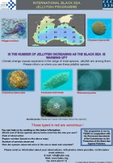
Floating ML and uncontrolled fishing nets represent particular threat to marine mammals (Zaitsev, 1998) which sometimes ingest inedible things and may get themselves entangled. A number of foreign bodies have been collected from stomachs of Black Sea common dolphins (Delphinus delphis): coal slag, pieces of wood and paper, bird feathers, cherry stones, and even a bunch of roses (Kleinenberg, 1956).
Widespread distribution of illegal, unreported and
unregulated (IUU) fishing in the Black and
National Consultants on ML problem presented basic reference data regarding maritime areas and seashores of the Black Sea riparian states (Table 1.2). This information is necessary for recognizing possible spread of ML in each country and, therefore, for planning ML research, monitoring and cleanup activities at the national level. Appropriate maps and schemes can be found in Annex 2.
The National Consultants summarized also available information on the coasts which are difficult of access for the purposes of ML monitoring and cleanup operations:
Russia: Cliffy and abrupt sites, sometimes
impassable, are common on the Russian Black Sea coast, particularly, round the
Abrau peninsula, between capes Panagia and Zhelezny Rog, Cape Doob and Golubaya
bay, Gelendzhik bay and Dzhoubga
settlement as well as in the outskirts of Tuapse city (e.g., capes Guavga and
Kadosh). Overall length of these difficult sections of the coast comes to
Turkey: There are coastal areas which are
difficult of access (mainly the indented coastline with vertical rocky shores
in places) between the Bulgarian border and Igneada (e.g., Igneada Longoz
located
Table 1.2. Characteristics of Black Sea maritime and seashore areas of the riparian countries
|
|
|
|
|
|
|
|
| Maritime areas, km2 | ||||||
| internal waters
|
1,474 |
|
58 b | 80 c |
– | 5,640 d |
| territorial sea | 6,506 |
1,204 | 5,270 | 7,800 e | 30,189.6 | 24,000 e |
| exclusive economic zone | 25,699 |
5,875 | ≈12,000 | ≈40,000
e |
172,991.3 | 91,000 e |
| shelf area (0-200 m deep) | 10,886 |
n.d. | n.d. | 3,800 | 19,360.4 | 48,600 |
| Depth range, m | ||||||
| internal waters
|
0–55 | 0–11 | n.d. | 0–10 f |
– | n.d. |
| territorial sea | 17–85 | 0–295 | 0–20 | 0–1,500 e |
0–1,987 | n.d. |
| exclusive economic zone | 40–130 | 200–1,900 | 20–100 | 200–2,200 | up to 2,267 |
n.d. |
| Coasts | ||||||
| coastline in total, km | 378 | 316.7 | 244 | |
1,446.2 |
1,802
h |
| seashore area in total, km2 | 6,429 | 11.2 | ≈750 | |
n.d. | n.d. |
a –
b – Danube delta;
c – Besides, Russian internal waters in the Kerch Strait and Azov Sea come to 5,370 km2;
d – Besides, Ukrainian internal waters in the Kerch Strait and Azov Sea come to some thousands km2;
e –
The delimitation of exclusive economic zones between
f – A depth of Russian internal waters
in the
Kerch
Strait and
g – In addition, Russian coastline and
seashore area in the
Kerch
Strait and
Azov
Sea
come to
h – This figure concerns the Black Sea coast only but not the Ukrainian coasts in the Kerch Strait and Azov Sea;
n.d. – no data were presented by the National Consultants.