At a glance ...
Title: People for Ecosystem Based Governance in Assessing Sustainable Development of Ocean and Coast
Instrument: Collaborative Project - Large-scale integrating project, FP7
Total Cost: 6 999 000 €
EC Contribution: 6 999 000 €
Duration: 48 months
Start Date: 01/01/2010
End Date: 31/12/2013
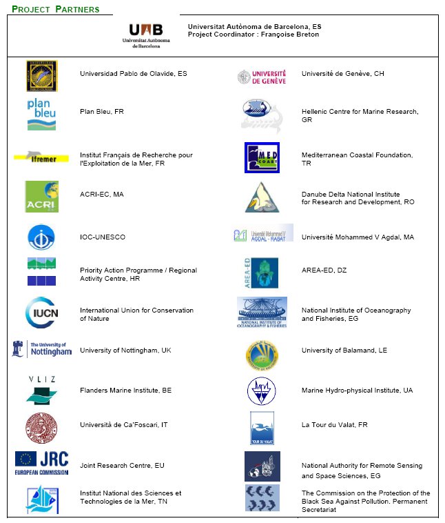
Consortium: 25 partners, 16 countries
Project Coordinator: Françoise Breton, Universitat Autònoma de Barcelona (Spain)
Phone: +34 93 581 35 49
E-mail: francoise.breton@uab.cat
Project Web Site: #pegasoproject
(operative since 2010)
Key Words: Ecosystem Approach, Integrated Coastal Management and Adaptive Spatial Planning
Many efforts have been deployed for developing Integrated Coastal Zone Management in the Mediterranean and the Black Sea. Both basins have, and continue to suffer severe environmental degradation. In many areas this has led to unsustainable trends which have impacted on economic activities and human well being. An important progress has been made with the launch of the ICZM Protocol for the Mediterranean Sea in January 2008. The ICZM Protocol offers, for the first time in the Mediterranean, an opportunity to work in a new way, and a model that can be used as a basis for solving similar problems elsewhere, such as in the Back Sea. PEGASO is consistent with the frameworks of the Barcelona and Bucharest Conventions which seek to achieve a coordinated approach to sustainable resource management and development, and to protect these regional seas and the quality of life of their peoples. It also continues ICZM efforts, supporting new marine and maritime policies.
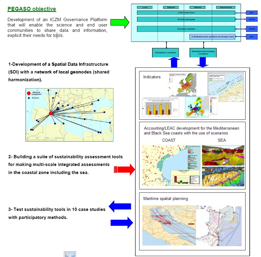
The main objective of PEGASO is to build on existing
capacities and develop common novel approaches to
support integrated policies for the coastal, marine and
maritime realms of the Mediterranean and Black Sea
Basins in ways that are consistent with and relevant to
the implementation of the ICZM Protocol for the
Mediterranean.
PEGASO will use the model of the existing ICZM
Protocol for the Mediterranean and adjust it to the
needs of the Black Sea through three innovative
actions:
-Constructing an ICZM governance platform as a bridge
between scientist and end-user communities, going far
beyond a conventional bridging. The building of a
shared scientific and end users platform is at the heart
of our proposal linked with new models of governance.
| POLICY |
Identifying common or complementary issues |
PEGASO Contribution |
| EU ICZM Recommendation (2002-2007) |
Already deals with land and its interface to the sea |
- Review of the set of ICZM indicators
|
| ICZM Protocol for the Mediterranean |
Modern policy and binding: linkages with ecosystem approach, maritime activities, spatial planning at land and sea, climate change impacts and risks, socioeconomic development, cultural identity, and their relationship to the sustainable development of the coast |
- Update of the ICZM indicators to measure sustainable development of the coast and building of an indicator of progress in ICZM
- Stocktaking to know how countries are prepared for implementation
- Governance Platform, sustainability tools and SDI
|
| Mediterranean Strategy for Sustainable Development |
Link with the Mediterranean Action Plan and the ICZM Protocol |
- Design and implementation of indicators for sustainable development
|
| Marine Strategy Framework Directive (MSFD) |
Ecosystem based, look for sea ecosystem |
- Gathering sea bed maps
- Developing a spatial indicator for "ecological potential"
- Measuring impacts from some maritime activities
|
| Maritime Spatial Planning |
Linked to ICZM. Key instrument for MSFD. MSP is used in some countries to implement MSFD (i.e. measuring impacts on ecosystems) |
- Stocktaking of maritime activities and future scenarios
- Identification and assessment of cumulative impacts on key spaces
- Participative decision making for spatial maritime planning
|
| Climate change adaptation (EU Green Paper) |
Impacts of climate change on costal settlements, activities and maritime uses Adaptative responses needed |
- Methodology for the vulnerability and risk assessment in coastal zones
- Guidelines for adaptation and mitigation strategies
|
| Halting biodiversity loss by 2010 |
SEBI 2010 indicators for the coast and sea |
- Implementing the relevant SEBI indicators in the Mediterranean and Black Sea
|
| Habitat Directives and Bird Directive |
-Natura 2000 sites aims to protect habitats and species, included birds
-National designation sites |
- Accounting for biodiversity loss in wetlands, islands and Marine Protected Areas (MPA)
- Urban impacts and intensive agriculture impacts on designated sites
|
| WFD |
Water and ecosystem quality standards |
- Development of indicators
- Development of land-sea scenarios on water and ecosystem quality
|
| Fisheries (specially ecosystem based management) |
Relation between fisheries, water quality and seascapes Special emphasis will be put on aquaculture practices. |
- Spatial integrated indicators and assessment on this issue
- Accounting ecosystem services such as aquaculture
|
| Horizon2020 |
Stop pollution in the Med in 2020 |
- Mapping of urban growth and scenarios
- Water use and management
|
| SEA Directive |
Plans and projects need a specific impact assessment to avoid degradation of landscape and ecosystems. |
- Development of impact indicators
- Identification of main future threats and priorities to mitigate them or to adapt
- Producing tools to be used in assessments
|
| Cohesion Funds |
Requires a clear vision of what is needed where, and a sustainability assessment to make a robust follow up of actions and investments. |
- Identify most vulnerable areas and issues for funding
- Identification of potentialities to be developed
|